< Previous | List | Next > To Tuxer-Joch-Haus
Click to enlarge!
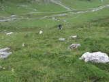

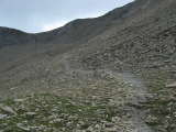
 Looking ahead at where the first part of the day's hike would take us
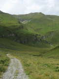
We awoke to largely overcast skies. Breakfast wasn't all that plentiful, and since the running water at Lizumer Hütte was not fit for drinking we had to make a small detour to get our water bottles filled for the day. We only set off in mid-morning - around 10am - but this was okay since we only had six and a half hours of hiking ahead of us. The first leg of the day's hike would take us through a green valley that was at times used for military testing or training. Since we had left so late, there were no other hikers to be seen anywhere. It wasn't until we reached the end of the trail that we realized that we ought to have climbed out of it to the left side a little while earlier. Rather than backtrack, we opted to just climb the grassy slope on our left, that way we'd be guaranteed to find the trail sooner or later.
Looking ahead at where the first part of the day's hike would take us
We awoke to largely overcast skies. Breakfast wasn't all that plentiful, and since the running water at Lizumer Hütte was not fit for drinking we had to make a small detour to get our water bottles filled for the day. We only set off in mid-morning - around 10am - but this was okay since we only had six and a half hours of hiking ahead of us. The first leg of the day's hike would take us through a green valley that was at times used for military testing or training. Since we had left so late, there were no other hikers to be seen anywhere. It wasn't until we reached the end of the trail that we realized that we ought to have climbed out of it to the left side a little while earlier. Rather than backtrack, we opted to just climb the grassy slope on our left, that way we'd be guaranteed to find the trail sooner or later.
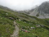
The climb was quite tiresome, but the positive aspect was that we managed to climb quite a bit in elevation while only covering a short distance. Some fifteen minutes later, we hit the trail again. From here, the going was easier, the trail was a foot-wide path that gently gained elevation through meadows and some rocks. The sky was still overcast, and at some point a few drops of rain fell. The views were still not bad, even though we were not able to see the top of the mountain pass we were supposed to go over. After slightly over an hour of hiking, we had reached the end of the valley, which meant that the climb would become steeper and rockier as we got closer to the saddle into the next valley.
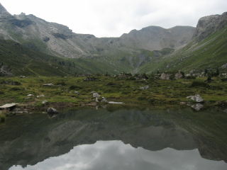
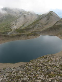
Progress got slower, since the gain in elevation was getting more dramatic, but the trail was still pretty easy - you had to be more careful on the rocks than on a footpath through meadows, but there was no exposure anywhere. Shortly after noon, we still hadn't reached the saddle, but were pretty much wiped out... a short break was in order. Thankfully, we'd been able to buy some snacks at the hut in the morning to give us an energy boost. Twenty minutes later, we had made it to the top of the "Pluderling-Sattel": so far today, we'd made 700m of elevation gain in slightly over two hours. From the saddle - which was being hit by cold winds, and we had to add another layer of clothing - we could see a blue Alpine lake ("Junssee"), and quite a bit of the hike to come. Unfortunately, it was cloudier up there, so that we couldn't see very far into the distance beyond the first mountain range behind the lake.
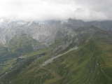
 Looking down at Junssee
I didn't quite like the descent to the lake - the trail went perpendicular to a scree slope that went all the way down to the lake. The slope had an angle of around 45 degrees, and in my still-present afraid-of-heights paranoia, I was picturing that I'd slip and then tumble all the way down to the lake. No such thing happened, and after about ten minutes the trail got easier again.
Looking down at Junssee
I didn't quite like the descent to the lake - the trail went perpendicular to a scree slope that went all the way down to the lake. The slope had an angle of around 45 degrees, and in my still-present afraid-of-heights paranoia, I was picturing that I'd slip and then tumble all the way down to the lake. No such thing happened, and after about ten minutes the trail got easier again.
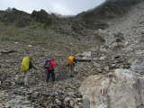
It was getting more and more overcast - although not worryingly so - and there was little to do but head on. The trail still lead us over high-mountain meadows and scree, gaining and losing some elevation along the way. On the way to "Gschützspitze-Sattel" - once again a scree-climb - we passed two older hikers who looked a little worse for the wear. I was told later than once I had passed them (and quite easily so), they made a disparaging comment about the type of shoes two in our group were wearing - trekking or trail-running shoes. But the truth is that in mixed terrain like this we were very obviously both faster and more secure in our steps than they were in their supposedly supperior mountain boots.
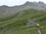
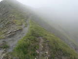
By the time we reached the saddle, we were fully engulfed in clouds. The trail that we had to follow from here looked slightly intimidating in the foggy light - hugging a steep grassy slope with lots of exposure to the right - but it would turn out that the expsoure wasn't as bad as it seemed at first sight, and as a consequence we had no trouble safely descending on the trail, which switchbacked down into the "Weidental" valley, losing 650m of elevation along the way.
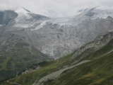
 Drying clothes at Tuxer-Joch-Haus, with a panorama view of the Tuxer glacier
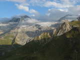
The Tuxer-Joch glacier on the other side of the valley was mostly hidden by clouds, but we were lucky enough in that we didn't get hit with any rain. Once we had reached the valley we took a small break and then started on the climb back up to the Tuxer-Joch-Haus, the mountain hut that would be our home for the night. At this point, the sun finally broke through the clouds, and afforded us better views. We reached the hut at around 5pm, and were able to finally see the glacier (or what little remains of it) in its entirely. Initially, we were put in one of the big "Lager" sleeping rooms, which was already full with people and we got the last remaining spots in the middle of the mattrasses on the ground. After dinner (where we consumed a lot, and thus probably gained in esteem compared to our more frugal fellow hikers) I asked the caretakers of the hut if we couldn't move to the adjacent sleeping room, which was empty. Initially, I was met with some resistance (they'd have to clean two rooms instead of one) but when I promised that we would keep everything tidy we had a big room - and more importantly, the four single beds that were in it - all to ourselves.
Drying clothes at Tuxer-Joch-Haus, with a panorama view of the Tuxer glacier
The Tuxer-Joch glacier on the other side of the valley was mostly hidden by clouds, but we were lucky enough in that we didn't get hit with any rain. Once we had reached the valley we took a small break and then started on the climb back up to the Tuxer-Joch-Haus, the mountain hut that would be our home for the night. At this point, the sun finally broke through the clouds, and afforded us better views. We reached the hut at around 5pm, and were able to finally see the glacier (or what little remains of it) in its entirely. Initially, we were put in one of the big "Lager" sleeping rooms, which was already full with people and we got the last remaining spots in the middle of the mattrasses on the ground. After dinner (where we consumed a lot, and thus probably gained in esteem compared to our more frugal fellow hikers) I asked the caretakers of the hut if we couldn't move to the adjacent sleeping room, which was empty. Initially, I was met with some resistance (they'd have to clean two rooms instead of one) but when I promised that we would keep everything tidy we had a big room - and more importantly, the four single beds that were in it - all to ourselves.
We were pretty unsure about the next day, since our two sleeping options for the next night were either closed or full, so we'd either have to detour or hike longer.
Written March 22nd in Bivange, Luxembourg.
Accommodation: Tuxer-Joch-Haus
- Kilometres hiked: 11km (6.8mi)
- Ascent: 1200m (3937ft)
- Descent: 900m (2953ft)