< Previous | List | Next > To Pfitcher-Joch-Haus
Click to enlarge!
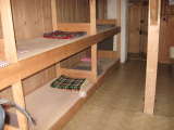
 I don't think either of us got a good night's sleep, since all that separated us from what might have been the world's loudest snorer were thin wooden planks. In fact, I'm almost persuaded that the wooden planks resonated with the snoring.
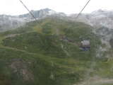
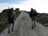
Once more, we were pretty late in leaving, and only left Tuxer-Joch-Haus shortly before 9am. We first lost some 300m of elevation on a dirt road, and then on the other side of the valley bought tickets to go up to Tuxer-Ferner-Haus in a comfortable cable car. Thus we gained 600m of elevation in about five minutes, rather than spending quite a bit more time following the switchbacks up the ski slopes below the Tuxer glacier ski area.
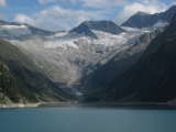
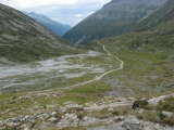
At the base of the summer ski area, we checked out the remains of the Tuxer glacier, which looked pretty pathetic to me especially since some of it was covered in white plastic, and then followed a trail to Spannagelhaus, the last building of any kind we'd encounter for the next few hours.
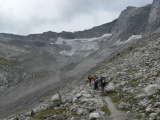
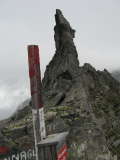
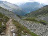
Our high point of the day would be Friesenbergscharte, at 2910m of elevation also the highest point of the entire trip. Since Spannagelhaus was at 2531m, that meant ascending around 400m. Initially, the trail was still somewhat level, but then quickly joined a very large talus field that we'd have to follow until almost the top.
The going was neither very easy nor too hard, and as such we made decent progress, reaching the Friesenbergscharte - the lowest point of the Tuxer Hauptkamm ridge - at about a quarter to twelve. The sky had been mostly overcast, but even though some of the clouds looked ripe with rain we didn't see any.
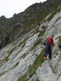
 The first look down the other side of the ridge looked very intimidating to me. The descent seemed to be almost vertical, and even though most exposed passages were secured with steel cables, I still had an overwhelming feeling of dread at the way that lay ahead. "I'm not going" was my first reaction, but then I reconsidered; subconsciously knowing that it couldn't be as bad as my mind made me believe. Patrick went first, and I followed him a short distance later.
Pretty soon, the first bad spots had been left behind without too much trouble, and Patrick and I had a considerable advance on Jacques and Ralph who had still lingered at the ridge. The going seemed to be quite easy and my confidence increased just as Patrick reached a spot with considerable exposure that looked intimidating. It was a smooth slab of rock, tilted at an angle, with a steel cable to the left and a steel spike to put the foot on, with a couple hundred metres of nothingness below. The problem for Patrick - being less tall than me - was that he had to lower himself down the cable more than he was comfortable doing in order to safely reach the steel spike with his foot. For a moment, he was stuck and did not dare move forward or back. I successfully talked him into stepping back up to a wider part of the trail, and then went over the difficult spot myself, finding it a little easier because of my advantage in body height.
Meanwhile, Jacques and Ralph had caught up with us. I was still below Patrick, so with his backpack off (to be carried over the bad spot by one of the two) and me doing my best to offer him guidance and offer a hand from below, we successfully got Patrick over the obstacle. Of course Jacques and Ralph mastered it without a second thought and not even a worry, proving once more that everything is relative. [In retrospect, I wish I had photographs of that spot, but at the time it seemed more prudent to leave the camera safely in my pocket.]
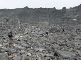
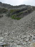
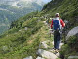
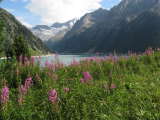
With the worst of the trail behind us, we continued hiking down, knowing we had a total of 1100m of elevation to lose before reaching Schlegeisspeicher, a water reservoir already visible in the distance. The trail wasn't particularly easy, because the descent was still quite steep (although without the exposure) and involved hiking on a lot of loose rocks of varying size.
We reached Friesenberghaus at around 1:30pm, and had a hearty and well-deserved late lunch. Since Olpererhütte was closed and Dominikushütte was full, our choices for the night were to either call it a day at 2:30pm or to continue hiking beyond the two logical stops for the night (which both were around 2 hours distant at this point). We opted for the latter, to hike an additional two hours to Pfitcher-Joch-Haus, meaning we still had around four hours of hiking ahead of us.
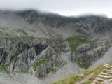
As clouds closed in on the Friesenbergscharte we had left behind, we continued hiking towards what looked like better weather. The next two hours would be moderately downhill, so we made good progress. An hour into the descent, we started seeing blue sky again, and gradually got rid of layers of clothing.