< Previous | List | Next > To Pisciaduhütte
Click to enlarge!
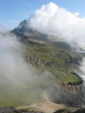
 Once more, we only left at around 9am. The hut was engulfed in clouds, and while the conditions weren't quite that of a white-out, we couldn't see very far at first. The trail was easy at first, hugging the left side of a mountain. At first the going was very smooth, but then as the sun started to pierce through the clouds there were a few rockier sections.
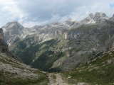
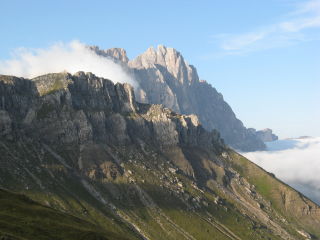
A quarter-hour after leaving, we finally were able to get some views of the surrounding mountains - even though they were still half-obscured by clouds, they looked spectacular in the morning sun.
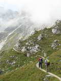
After about an hour of hiking, Forcella de la Roa first came into view. We'd still have to climb some 300m of elevation to get to the top; but spirits were high and we were going at a decent pace, overtaking some other hikers. Fifteen minutes later, we hit the scree field that marks the start of the final ascent. At first there were still some stone steps, but after that we quickly came upon a number of switchbacks over fairly loose stones. Hiking poles definitely helped, and we made it to the top of the pass in less than an hour and forty-fives minutes, three quarters of an hour faster than our guide book had indicated.
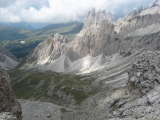
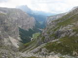
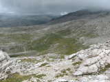
At the Forcella de la Roa we were able to get a glimpse into the Val Roa. Here, we had a minor disagreement on what route to take - the easiest and most straightforward would be to go through the short via ferrata to Forcella Nivea. I advocated this option, but Patrick and Ralph preferred to go the long way around, descending about 150m into Val Roa. They'd rejoin the trail after around 1km as the crow flies, while I took off for a 100m elevation gain to Forcella Nivea.
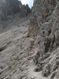
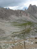
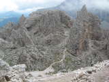
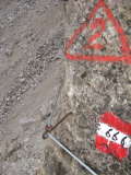
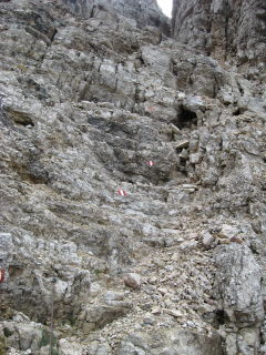 At first, I crossed another scree field, then quickly came upon the first iron cables. Not having any means to clip myself into these cables, I was slightly concerned at first since there was some climbing to be done and a slip or fall here would have lead to serious injuries at least. I climbed around a larger stone which I considered to be the hardest part, since there was only a small ledge on which to put your feet, the iron cables to hold on to, and many metres of empty space behind my back... Obviously, during this maneuver I preferred not to have the camera out. But soon enough the trail levelled out already, and required nothing more than some scrambling before leading to an iron ladder. Once at the top of the ladder, I could almost see where the trail topped out, and the remainder of the way was effortless.
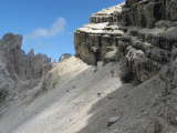
The views of the Val Roa were impressive from up here, even though there was an increasing number of clouds.
I rested for about twenty minutes, during which time I sent a text message to Patrick to let them know I was alright (which in fact he'd only receive much later) and then started the descent, down almost 300m towards Rifugio Puez.
I made excellent progress, hiking much faster than the other people I encountered on the trail. After I lost most of the elevation and the trail leveled out, I was once more surrounded by clouds and after a while it started raining. I put the rain cover on my backpack, and rigged my umbrella to the shoulder strap; which enabled me to keep up my fast pace while simultaneously not having to worry about getting wet.
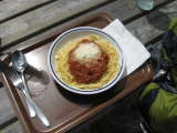
At around 12:40, I arrived at Rifugio Puez, half expecting to already see the two others there. I didn't see them, but the refuge was packed with hikers who had tried to escape from the rain. Less than ten minutes later however, there was once again some blue sky overhead; and after some more waiting I decided to have something to eat while waiting for my hiking companions to show up. No sooner did I sit down with my spaghetti, and they showed up. I don't remember specifics, but I think Ralph had some choice words for me for making it to the hut sooner than them.
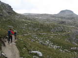
We ate, and then at around 13:30 took off again. The weather still wasn't all that great, and we spent the next half hour either in the clouds, or getting rained on (albeit lightly). By 2pm, the weather had improved slightly. We were still following the same trail that took us over the Crespeina high plateau. There were some intermediate high-points on the way, but neither brought an important elevation gain or loss.
We lost about a quarter-hour at Cir-Joch, the last high-point before descending towards Grödner Joch (Passo Gardena), when Ralph took his time talking to an Italian tourist; even though neither Patrick nor I were too involved in said discussion.
At 4:10pm, we had reached the Passo Gardena mountain pass. Our guide book suggested spending the night here, but we opted to still push on to the Pisciadu Hut, which was located some 450m of elevation higher. I must confess that I was the driving force behind this decision, and in hindsight we really should have stayed were we were at 4pm.
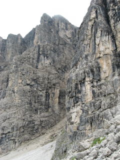 As is, we were trying to gain those final 450m of elevation as fast as possible. The sky was mostly overcast at first, and we weren't yet worried. After following a tame single-track mountain path, we reached the entrance of the Val Settus at 4:35pm. Val Settus is a steep valley flanked by steep mountain walls on two sides, and filled with scree at around a 45 degree angle. The trail zig-zagged up this valley, and we were a little surprised to hear some thunder in the distance. We briefly discussed the situation: should we head back down, or would it be faster to head up to the safety of the mountain hut? We guessed that we would spend less time out in the open if we headed up. In hindsight, again, this wasn't the smartest decision.
We weren't the only ones on the trail, however; and by 5pm we were definitely beyond the half-point. Turning back or heading on was now a split-decision. By now, Ralph was leading by quite a large margin, as Patrick and I had lost some steam and were struggling to keep up with the pace.
The weather was deteriorating, but we were not yet in the center of the thunderstorm. Just when we thought we'd reached the end of the valley, the real crux of the climb was still ahead: a via ferrata - a section secured by iron cable. We were now engulfed by clouds, and by now I was worried. Patrick was climbing just ahead of me, and he didn't seem to be at ease. At one point, he lost grip on his hiking poles, and they clattered down a few meters. He was alright, though, and I picked up his poles and we continued climbing.
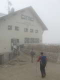
Fifteen minutes after reaching the hardest section, we had finally made it to the top. By now, we knew we were very close to the hut; and it was none too soon because it was now starting to hail and snow. At 5:25pm, we reached the safety of the hut; and it turns out we weren't the last group to arrive that evening either.
First part written 26.03.2009 in Bivange, finished 04.07.2009.
Accommodation: Pisciaduhütte
- Kilometres hiked: 20km (12.4mi)
- Ascent: 950m (3117ft)
- Descent: 1250m (4101ft)